Hurricane Irma is days away from possibly touching American shores and has strengthened to an "extremely dangerous" Category 5 storm, according to the National Hurricane Center.
A storm advisory says maximum winds have reached 185 mph, placing Hurricane Irma as a Category 5 storm on the Saffir-Simpson scale. Irma is moving west at 15 mph, but the center said it's still too early to determine what effects Irma might have on the continental U.S.
An overlay from KXAS-TV (NBC5) meteorologist Brian James showed a storm the size of the Lone Star State.
The storm measured 785 miles wide Tuesday night, NBC5 meteorologist Rick Mitchell said, noting that Texas stretches 720 miles from El Paso to the border near Shreveport.
Overlaying an image of #Irma over the state of Texas to give you an idea of the size of the hurricane. pic.twitter.com/EmfBWHYbJ3
— Brian James (@BrianJamesNBC5) 5 September 2017
Mitchell said a ridge of high pressure that has formed will likely keep the storm away from Texas.
"Hurricanes are like water, they're going to look for a path of least resistance," he said. "The ridge of high pressure is kind of like that. It's not favorable to bring this storm in our direction."
In fact Texas is likely to stay dry over the next few days thanks to a cold front that is dropping highs to the mid-to-upper 80s and lows in the 60s through Sunday.
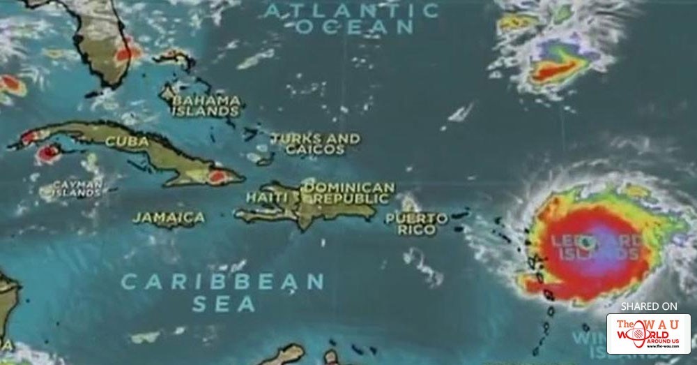
A probable path for Irma shows the storm possibly reaching Caribbean islands about 2 a.m. Wednesday and Cuba by 2 a.m. Sunday, where it could possibly affect southern Florida and the Keys.
“Some fluctuations in intensity are likely during the next day or two, but Irma is forecast to remain a powerful Category 4 or 5 hurricane during the next couple of days,” the center’s public advisory said.
Hurricane warnings are in effect for many islands including the U.S. Virgin Islands and Puerto Rico. A hurricane watch is also in effect for Turks and Caicos, Guadeloupe and the Dominican Republic.
Bahamas Prime Minister Hubert Minnis said his government has ordered a mandatory evacuation of islands in the southern part of the island chain because of Hurricane Irma.
People who live on the islands of Mayaguana, Inagua, Crooked Island, Acklins, Long Cay and Ragged Island will be flown Wednesday to Nassau on the island of New Providence. Minnis says it will be the largest hurricane evacuation in the history of the Bahamas.
People who don't evacuate will be at "great danger" from storm surge caused by what he called a "monster" hurricane. Minnis says emergency personnel may not be available to rescue them when the storm is at its height between Thursday and Friday.
U.S. President Donald Trump declared emergencies in Florida, Puerto Rico and the U.S. Virgin Islands.
Category 5 #Irma with 185-mph winds- #Hurricane preparations in the NE Leeward Islands should be nearing completion https://t.co/tW4KeGdBFb pic.twitter.com/tMhL53YX5I
— NHC Atlantic Ops (@NHC_Atlantic) 5 September 2017
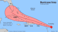
The storm seemed almost certain to hit the United States by early next week.
"You'd be hard pressed to find any model that doesn't have some impact on Florida." said University of Miami senior hurricane researcher Brian McNoldy.
Gov. Rick Scott activated 100 members of the Florida National Guard to be deployed across the state, and 7,000 National Guard members were to report for duty Friday when the storm could be approaching the area. On Monday, Scott declared a state of emergency in all of Florida's 67 counties.
11 pm AST forecast and key messages for Hurricane #Irma. Go to https://t.co/tW4KeGdBFb for the latest forecast. pic.twitter.com/ozQfx3hdRB
— NHC Atlantic Ops (@NHC_Atlantic) 6 September 2017
Officials in the Florida Keys geared up to get tourists and residents out of Irma's path, and the mayor of Miami-Dade county said people should be prepared to evacuate Miami Beach and most of the county's coastal areas.
Mayor Carlos Gimenez said the voluntary evacuations could begin as soon as Wednesday evening. He activated the emergency operation center and urged residents to have three days' worth of food and water.
Here are the latest estimates of when tropical-storm-force winds could arrive & are most likely to arrive with #Irma https://t.co/tW4KeGdBFb pic.twitter.com/lphk4Nm9x8
— NHC Atlantic Ops (@NHC_Atlantic) 5 September 2017
Share This Post


