MORE than a month’s worth of rain drenched parts of Sydney this morning, damaging homes, threatening an apartment building with collapse and causing transport chaos.
An apartment building in the inner west suburb of Marrickville was evacuated, amid fears it would collapse into a flooded water hole behind it.
A home in Tennyson Point, also in the inner west, collapsed, while the NSW State Emergency Service received more than 140 calls for help to repair damage caused by torrential rains.
NSW Fire and Rescue crews were also kept busy.
#FRNSW crews responded to about 200 incidents between 10am-1pm today. Most storm-related call-outs were in the inner-Sydney area.
— Fire & Rescue NSW (@FRNSW) February 7, 2017
SES volunteers were also called to rescue 13 motorists stranded in flood waters at the height of the flooding, which brought some parts of the city to a standstill.
A member of the public reported concerns for the Marrickville building’s structural integrity, about 1.30pm, prompting SES volunteers, police and rescue firefighters to rush to assess the damage.
They evacuated 17 residents from the three level apartment block in Ewart Street about 1.30pm.
The residents are unlikely to return home tonight but rescue firefighters who have examined the building say it is not likely to collapse.
MARRICKVILLE | 17 ppl evac'd from unit block as precaution. Blding sound at this stage. Monitoring set up. Engineers assessing. #FRNSW
— Fire & Rescue NSW (@FRNSW) February 7, 2017
NSW SES spokeswoman Becky Golling told news.com.au a member of the public phoned emergency services to report the precarious situation of the building.
“Police and also Fire and Rescue are on scene, assessing situation to see how serious it is,” she said.
“They are trying to determine whether this building will collapse in to a water hole behind building.”
Marrickville resident Geoff, who reported the incident to the SES, told Fairfax Media: “I’ve never seen anything like the rain today”.
One resident took video of the downpour at the apartment block.
One resident has shared video of floodwaters impacting the building that was evacuated at Marrickville @2GB873 pic.twitter.com/wzVtR5zohN
— Matthew Karstunen (@MKarstunen) February 7, 2017
Evacuated apartment block in Marrickville, threatening to collapse into water hole behind it. pic.twitter.com/TDlRiHUuZF
— Daniel Sutton (@danielsutton10) February 7, 2017
Initial reports from emergency services were that up to 100 people could be inside.
The call was just one of several fielded by the state’s emergency crews this morning.
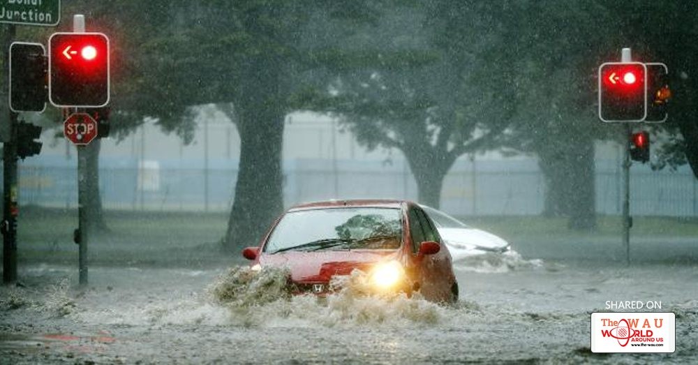
The deluge caused widespread flash flooding, road closures and transport chaos.
SES crews were called throughout the morning to rescue motorists from flood waters and repair damaged homes.
There were 13 calls for rescue, mainly in the city’s inner west, which copped the worst of the rainfall,
There were a further 140 to attend damaged and leaking homes.
Among them was a house in Tennyson Point, in Sydney’s north west, where the front part of a home collapsed.
No-one was home at the time.

The deluge also caused extensive delays across the public transport network, with bus, train and light rail services all impacted.
Inner west buses were delayed by up to an hour at the peak of the flooding and some roads across the city remain closed or gridlocked as rains continue to fall.
The weather bureau is forecasting the rain to continue falling throughout the day and into tomorrow.
A severe thunderstorm warning was issued just before midday but cancelled an hour later.
There remains in place a thunderstorm warning for heavy rainfall and damaging winds.
Flooded roads caused chaos for motorists and there are continuing delays on bus and train routes.
James Ruse Drive and Parramatta Rd flooded and the Anzac Bridge was gridlocked, though traffic started moving again when floodwaters subsided.Take it easy out there, a lot of rain around.. Here's how it looks at Rushcutters Bay right now.
— Lawrence Champness (@champy) February 7, 2017
Photo by Andrew Macindoe.#Sydney pic.twitter.com/lPaNYyaXdP

Buses to and from Drummoyne and Rozelle were suffering delays of up to an hour at the peak of the rainfall due to being diverted around Anzac Bridge.
As of 2pm, there remained residual delays of up to 30 minutes on those routes.
Trains on the T2 line were not stopping at Lewisham station due to flooding in the subway but resumed about 1.30pm.
Buses in Drummoyne & Rozelle are delayed upto 1 hr due to heavy traffic on Western Distributor, Anzac Bridge & Victoria Rd.
— Buses Inner West (@BusesInnerWest) February 7, 2017
#InnerWestLine: Trains to the city will not stop at Lewisham. Pls travel to Petersham & change to complete your journey. #SydneyStorm.
— T2 Sydney Trains (@T2SydneyTrains) February 7, 2017
Flights have also been impacted at the airport, where heavy rain has fallen.
A Fire and Rescue NSW spokeswoman told The Daily Telegraph crews had been swamped with requests for help, as the storm caused roofs to cave in, homes to flood and cars to become trapped.

“On Wentworth Rd in Glebe the water has been reported up to one metre deep and there are requests for a vehicle to be towed out,” the spokeswoman said.
“We urge people to stay away from flood waters and not risk their safety by trying to drive through flood waters or walk through them.”
The city, the inner west and the east suffered the heaviest falls.
More than 50mm has fallen at the city’s Observatory Hill meteorological site since 9am, while the airport has had 30mm.
Nearby Canterbury has had 51.2mm.
There were flight delays, diversions and cancellations at Sydney Airport.
⚠ Delays, diversions and cancellations are likely due to #SydneyStorm.
— Sydney Airport ✈️ (@SydneyAirport) February 7, 2017
Please check with your airline for latest flight status updates. pic.twitter.com/4VNAv9paQh
More is on the way, according to the Bureau of Meteorology.
A severe thunderstorm warning was issued just before noon but cancelled an hour later.

However, a warning for heavy rainfall and damaging wind remains.
Forecaster Mohammed Nabi said more heavy rain is expected throughout the day and into tomorrow.
“The thunderstorms combined with the humid air over the city is causing this,” he told the Daily Telegraph.
“When you get these sorts of downfalls, they can cause flash flooding in built-up areas.”
The rainfall came as initial welcome relief for Sydneysiders, after a sweltering heatwave swept across the city late last week and across the weekend.
Temperatures in the city reached the mid to high 30s across most of the weekend and barely dropped below the mid 20s most nights.
However, the relief soon turned to frustration for many residents, with heavy rain impacting morning commutes for many inner city residents.


Share This Post


